Switzerland during the last Ice Age
Artists
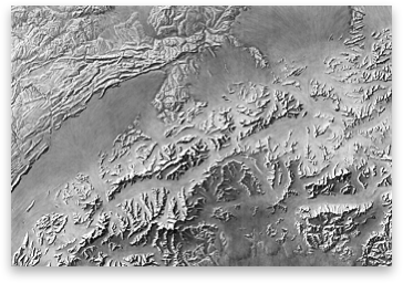
Heinz Leuzinger.Creation Date
July 1969 to January 1970.Scale and Size
Original art scale: 1:454,545.Digital art size at 400 DPI, 11,902 × 8,945 pixels.
Terms of Use
No use restrictions. The shaded relief is in the public domain. Space permitting on your map, please cite Heinz Leuzinger (Institute of Cartography and Geoinformation ETH Zurich) as the author.Georeferencing
None.Release Date
June 2011Additional Information
This shaded relief image was created for the map "Die Schweiz zur letzten Eiszeit", 1:500,000, sheet 6 of the former Atlas of Switzerland. This map shows Switzerland with the maximum glacial extension during the last ice age, around 15,000 to 20,000 years ago. Content by Heinrich Jäckli (Zurich), map by Eduard Imhof and Heinz Leuzinger, 1970.This map does not reflect the latest knowledge on glaciation during the ice age. There is the more up-to-date map “Switzerland during the Last Glacial Maximum (LGM), 1:500,000” produced in 2009 by swisstopo. This map shows the maximum extent of glaciation in Switzerland at the height of the last Ice Age about 24,000 years ago. A digital version of the map is available for free from www.swisstopo.admin.ch > Products > Maps > Geological maps > Geological maps 1:500,000.
Download

88 MB
TIFF file