Alaska–Townsend
Artist
Kenneth Townsend, PA, USACreation Date
1985Scale and Size
Original art scale and size: Not knownPublished map scale: 1:17,000,000
Cropped digital art size: 18.82 × 11.69 cm at 400 DPI,
2,963 × 1,841 pixels
Terms of Use
No use restrictions. The shaded relief is in the public domain. Space permitting on your map, please cite Kenneth Townsend as the source.Georeferencing
Albers Equal-Area Conic ProjectionStandard Parallel 55N and 65N
Central meridian: 147W
Latitude of projection origin: 50N
NAD83 Datum
Map Compatibility
Relief art modified by Tom Patterson to register with 1:10 million Natural Earth vectors: www.naturalearthdata.comThe relief download includes a Natural Earth coast shape file with embedded projection information.
Release Date
September 2011Additional Information
R. R. Donnelley and Sons Cartographic Services commissioned the creation of this shaded relief under the supervision of Herwig G. Schutzler. The Cartographic Services unit at R.R. Donnelley is now defunct. Upon going out of business, Donnelley transferred ownership of the relief art to GeoSystems Global Corporation, which later became MapQuest, owned by AOL. When MapQuest sold off their custom cartography unit, GeoNova, a successor company, became the new owners of the relief. GeoNova has since failed. Herwig G. Schutzler then donated this relief to the U.S. Library of Congress, where it is permanently stored along with other Donnelley relief art.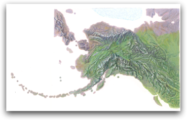
Download

7 MB
GeoTIFF with World file and coast shape file