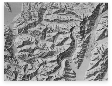
Mount Cook, New Zealand
Artist
William (Bill) Drake, New Zealand and USACreation Date
Circa 1992Scale and Size
Original art scale: 1:50,000Original art size: 82.9 × 62.6 cm
Released digital art size: 82.9 × 66 cm at 300 DPI,
9,795 × 7,792 pixels
Terms of Use
The shaded relief is in the public domain. When using the relief, please cite William Drake and Department of Survey and Land Information/Land Information New Zealand.Georeferencing
None. The relief is in the New Zealand Map Grid projection, Geodetic Datum 1949, International Spheroid.Release Date
January 2012Additional Information
The shaded relief provided here is a scan of a photographic reproduction printed on lightweight paper. William Drake’s widow Janet Peacock provided the paper print to ShadedReliefArchive.com.William Drake prepared the relief for the Department of Survey and Land Information, (now Land Information New Zealand), the national mapping agency of New Zealand. It was published on topographic map 260 sheet H36 in 1992. Map detail was revised in 1994 and 1996, but the relief shading remained unchanged. This 1:50,000 scale topographic map is part of a now obsolete English units series (this series was superseded by the metric NZTopo50 series in 2009). Land Information New Zealand has kindly allowed this website to publish the Mount Cook relief online.
Download

50.6 MB
TIFF file