Graubünden NW, Switzerland
Artists
Eduard Imhof and Heinz Leuzinger, ETH Zurich.Creation Date
1963 or before.Scale and Size
Original art scale and size: not known.Digital art size: 96.39 × 76.91 cm at 400 DPI,
15,180 × 12,112 pixels
Terms of Use
No use restrictions. The shaded relief is in the public domain. The original is stored at the Library of ETH Zurich.Georeferencing
None.Release Date
December 2011Additional Information
This is the northwest part of a shaded relief drawn in four parts. The southwest part is also available at ShadedReliefArchive.com. The whereabouts of the two eastern parts are unknown. The complete shaded relief was used for a school wall map of the Canton Grisons (“Schulwandkarte des Kantons Graubünden”, 1:100,000, 1963), and for a school map of the same area (“Schulkarte des Kantons Graubünden”, 1:250,000, 1964, also published as “Reisekarte des Kantons Graubünden”, 1:250,000, 1964, published by the Rhätische Bahn). A section of this northwest part was also used for a map of Vorarlberg (“Land Vorarlberg”, 1:200,000, 1963). All mentioned maps were printed by Art. Institut Orell Füssli, Zürich.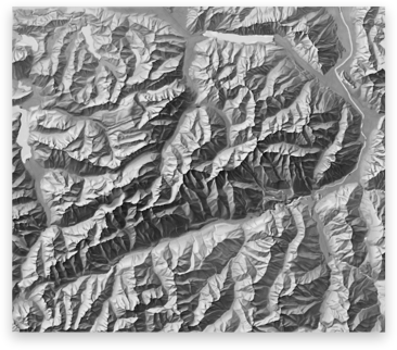
Download

115.5 MB
TIFF file